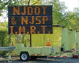
NJDOT promotes a real-time
portable travel information system
NJDOT is providing new technology for motorists to receive speed and road condition information as they drive. This alerts drivers to upcoming roadwork, accidents and inclement weather, and provides travel time through a specific section of roadway quickly and accurately.
Here’s how it works.
NJDOT places portable trailers and sensors along the road that use radar to read traffic speeds in both directions. Each sensor can read up to eight travel lanes. Once the sensor detects the average speed, it sends it to a main computer and then runs it through an algorithm to calculate the travel time through the area. |
 Portable trailers carrying dynamic signs (DMS) about driving conditions help motorists as they travel.
 |
NJDOT places the information on Dynamic Message Boards (DMS) along the side of the highway and integrates it into a Google map that shows the locations of all sensors and DMS at njcommuter.com. Statewide Traffic Operations currently uses this system on roadways in Union and Essex counties (I-78), in Gloucester and Camden counties (I-295) and in Middlesex County (I-287 Stelton Road).
Going hi-tech on the highway is nothing new for the Department’s Traffic Operations Centers in Elmwood Park and in Cherry Hill, who have utilized information from 206 traffic cameras placed throughout the state for display on our Web site’s real-time traffic reports.
NJDOT also communicates travel conditions through a voice interactive 511 travel information telephone number and our Highway Advisory Radio stations.
|

